| www.lfweathercenter.com | www.lfradar.com HOME |
- Home
- Radar
- Forecast
- Severe Outlook
- Satellite
- Maps
- Graphs
- Gauges
- Reports
- History
- Nearby WX
- Links
- About
- Site Map
| L I B E R T Y F A I R F I E L D W E A T H E R C E N T E R | |
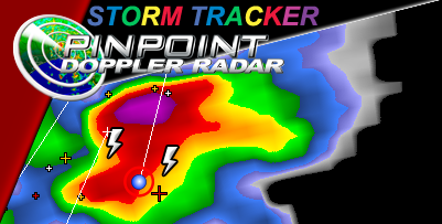 |
B U T L E R C O U N T YT R I P L E R A D A R |
| - Base Reflectivity -- KILN / KIND / KLVX - | |
| current NWS Level 3 radar status |
Non Precipitation Light Moderate Heavy Very Heavy Extreme 
|
 |
 |
 |
| Warning Box Colors: Flash Flood Severe Thunderstorm Tornado Page loaded: 2026/07/26 - 20:37:30Z |
| CAUTION: Always check time-stamp to verify latest radar image is being displayed ↑ ↑ ↑ ↑ ↑ ↑ ↑ ↑ ↑ ↑ ↑ ↑ ↑ ↑ REFRESH your browser if a more current image may be available |
| Warning Boxes are updated when a new radar image is available (could be delayed up to 5 minutes) |
| S t o r m M a r k e r L e g e n d Storm Tracks are one hour in length Marker locations are approximate & may be delayed Heavy Rain, Hail or Damaging Winds may precede the storm core. 
|
| Click HERE for a list of Storm Report Icons and sample warnings |
Never base important decisions on this
or any weather information obtained from the Internet