|
|
|
- Home
- Forecast
- Severe Weather Outlook
- Satellite
- Maps
- Graphs
- Gauges
- Reports
- History
- Links
- About
- Site Map
- Mason MI
LIBERTY FAIRFIELD WEATHER CENTER |
Liberty Township / Fairfield Township / Butler County - Hamilton, Ohio, U.S.A. |
Now: 80°F |
||
| Hazardous Weather Outlook Heat Advisory |
Feels Like: 86°F |
|
|
Today Chance T-storms |
Tonight Chance T-storms |
||
Current Conditions Updated: 4:07am 7/25/25
| Hi 91 °F | Lo 73 °F |
Good Morning,
|
| ||||||||||||||||||
|
C U R R E N T W E A T H E R I N D I C E S
|
|||
- Comfort Index -
|
- Humidity Index -
|
- Heat Stress Index -
|
- Frostbite Time -
|
| Forecast: Today through Saturday |
|
Sunrise: 6:33am Sunset: 8:58pm
|
| National Weather Service Local Forecast issued at 1:22 am EDT Jul 25, 2025 |
| Today Chance T-storms |
Hi 91 °F A chance of showers and thunderstorms, mainly after 2pm. Mostly sunny, with a high near 91. Heat index values as high as 100. Light and variable wind becoming west around 6 mph in the morning. Chance of precipitation is 40%. New rainfall amounts between a tenth and quarter of an inch, except higher amounts possible in thunderstorms. |
Tonight Chance T-storms |
Lo 73 °F A chance of showers and thunderstorms, mainly before 2am. Mostly cloudy, with a low around 73. Calm wind. Chance of precipitation is 30%. New rainfall amounts of less than a tenth of an inch, except higher amounts possible in thunderstorms. |
Saturday Chance T-storms then T-storms Likely |
Hi 91 °F Showers and thunderstorms likely, mainly after 2pm. Partly sunny, with a high near 91. Calm wind becoming southwest around 6 mph in the afternoon. Chance of precipitation is 70%. New rainfall amounts of less than a tenth of an inch, except higher amounts possible in thunderstorms. |
|||||||
| 48 Hour Temperature Forecast |
||||||||||||
| 48 Hour Precipitation Potential Forecast |
||||||||||||
| Select Graph for Full Forecast | ||||||||||||
S E V E R E W E A T H E R I N F O R M A T I O N
|
||
- Local Radar -
|
- Current Weather Statements -
|
- Severe Weather Outlook -
|

|

|
 - National Weather Service Data Feeds - Wilmington, OH Weather Statements Indianapolis, IN Weather Statements Louisville, KY Weather Statements |
|
|||||||||


|
COUNTDOWNS:
173 days until the average COLDEST HIGH temperature of the year 184 days until the average COLDEST LOW temperature of the year 360 days until the average WARMEST HIGH temperature of the year 362 days until the average WARMEST LOW temperature of the year 38 days until Meteorological Autumn 129 days until Meteorological Winter 219 days until Meteorological Spring
38 days until Labor Day
125 days until Thanksgiving
153 days until Christmas
196 days until the 2026 Winter Olympics |
 |
|
|
|
||||||||||||||||||||||||||||||||||||||||||||
|
|
|||||||||||||||||||||||||||||||||||||||||||||


W E A T H E R A L M A N A C
|
||||||||
- T O D A Y -
|
- Y E S T E R D A Y -
|
|||||||
Since
Midnight |
Record
Coldest |
Normal
|
Record
Warmest |
Temperature
Yesterday |
Record
Coldest |
Normal
|
Record
Warmest |
|
High Temperature
|
83.6°
|
71°
|
87.0°
|
107°
|
94.6°
|
72°
|
87.0°
|
106°
|
Mean Temperature
|
81.8°
|
-
|
75.8°
|
-
|
82.4°
|
-
|
75.8°
|
-
|
Low Temperature
|
79.9°
|
55°
|
64.6°
|
79°
|
70.3°
|
54°
|
64.6°
|
80°
|
Daily Precipitation
|
0.00"
|
Record Rain
1.87" |
Record Snow
0.0" |
0.00"
|
Record Rain
2.56" |
Record Snow
0.0" |
||
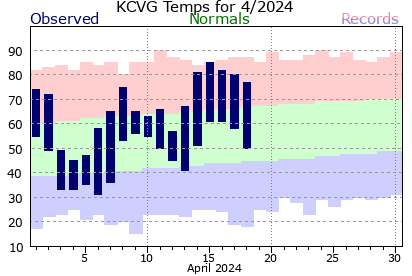
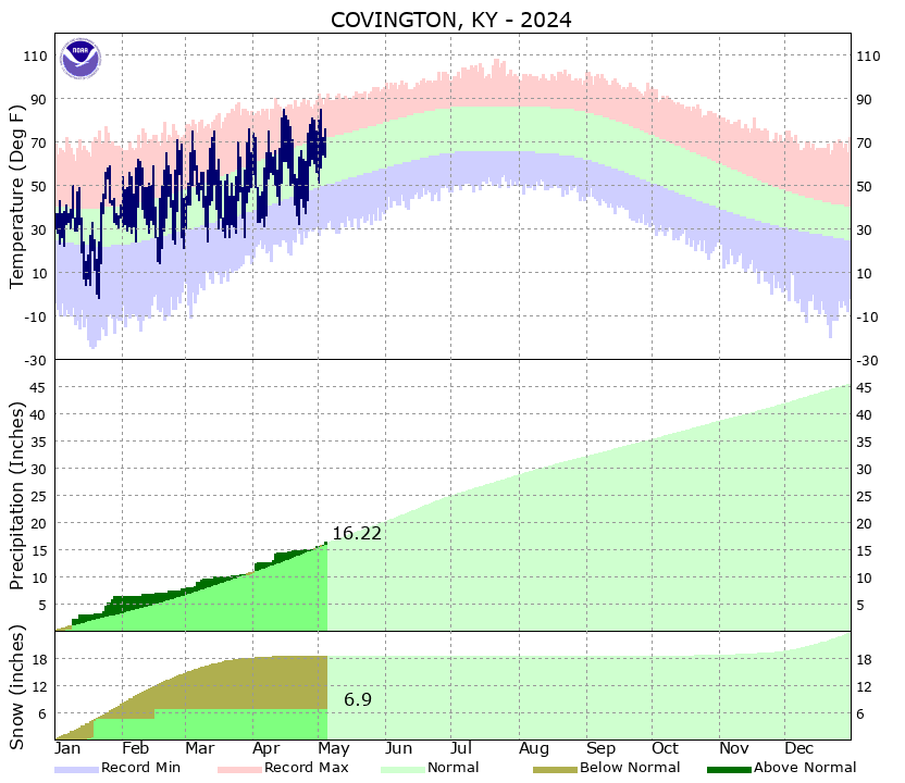
| * "Normals" are 30 Year Average values at the Butler County Regional Airport (3.2 miles to the southwest). "Records" are at Cincinnati, Ohio. (25 miles to the south-southwest). |
S U M M A R Y F O R Y E S T E R D A Y
|
|||
|
| * "Normals" are 30 Year Average values at the Butler County Regional Airport (3.2 miles to our southwest). "Records" are at Cincinnati, Ohio. (25 miles to our south-southwest). |
M I S C E L L A N E O U S I N F O R M A T I O N |
|||||
Hourly Rain per Acre |
Daily Rain per Acre |
24 Hour Rain per Acre |
Yesterday's Rain per Acre |
Monthly Rain per Acre |
Annual Rain per Acre |
undefined gallons |
undefined gallons |
undefined gallons |
undefined gallons |
undefined gallons |
undefined gallons |
Water Boiling Point |
Current Rainfall Rate per Acre |
Density Altitude |
Pressure Altitude |
Vapor Pressure |
Virtual Temperature |
° |
undefined gallons/hr |
feet |
feet |
" Hg |
° |
D a v i s V a n t a g e P R O 2 - W E A T H E R S T A T I O N G E N E R A T E D F O R E C A S T
|
| (Updated Hourly) |
| The Davis Vantage PRO 2 Weather Station uses a sophisticated forecasting algorithm which takes into account Barometric Pressure, Wind, Rainfall, Temperature, Humidity, Latitude and Longitude. The result is a much more accurate forecast. Not perfect, but much better than many other Personal Weather Stations. |
| Additional Weather News and Links |
|
Local Interactive Weather Map EF1 Tornado in Liberty Township May 26th, 2011 |
| Weather Data from this station is contributed to the following organizations: |
Citizen Weather Observer Program Station ID: DW1039 |
 Community Collaborative Rain, Hail & Snow Network Station ID: OH-BT-1 |
 Weather For You / PWS Station ID: DW1039 |

Midwestern Weather Network

Weather Underground
Station ID: KOHHAMIL7

Never base important decisions on this or any weather information obtained from the Internet
Updated Automatically by Ambient Weather's Virtual Weather Station
Data Collected using a Davis Vantage Pro2 Weather Station
Weather Advisory & Forecast Scripts courtesy of saratoga-weather.org
1201 days until the next presidential election 1275 days until the next presidential inauguration day